
FORT WAYNE, Ind. (ADAMS) – A heat dome is bringing extreme temperatures and humidity to more than 200 million Americans.
Extreme heat watches, warnings, and advisories are already in effect for the parts of the Southwest, Rockies, Plains, Upper Midwest, and Northeast. Nebraska, Colorado, South Dakota, and Iowa could see new temperature records on Friday.
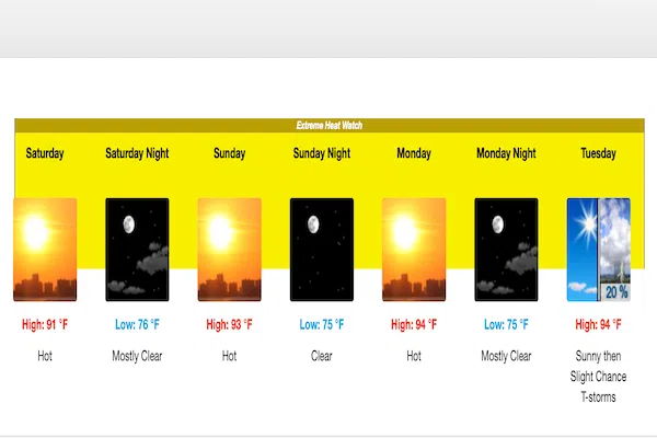
Here in northeastern Indiana, we will start to feel the extreme heat on Saturday. The National Weather Service has issued an Extreme Heat Watch for our area.
See the full forecast HERE
The National Weather Service released the following:
Elkhart-Lagrange-Steuben-Noble-De Kalb-Starke-Pulaski-Marshall-
Fulton IN-Whitley-Allen IN-White-Cass IN-Miami-Wabash-Huntington-
Wells-Adams-Grant-Blackford-Jay-Northern La Porte-Eastern St.
Joseph IN-Northern Kosciusko-Southern La Porte-Western St. Joseph
IN-Southern Kosciusko-Cass MI-St. Joseph MI-Branch-Hillsdale-
Northern Berrien-Southern Berrien-Williams-Fulton OH-Defiance-
Henry-Paulding-Putnam-Van Wert-Allen OH-
355 AM EDT Fri Jun 20 2025 /255 AM CDT Fri Jun 20 2025/
…EXTREME HEAT WATCH REMAINS IN EFFECT FROM SATURDAY MORNING
THROUGH TUESDAY EVENING…
* WHAT…Dangerously hot conditions with heat index values between
95 and 106 possible. The hottest conditions are expected on Sunday
and Monday.
* WHERE…Portions of northern Indiana, southwest Michigan, and
northwest Ohio.
* WHEN…From Saturday morning through Tuesday evening.
* IMPACTS…Heat related illnesses increase significantly during
extreme heat and high humidity events.
* ADDITIONAL DETAILS…Consecutive days of excessive heat and
humidity combined with very warm low temperatures in the 70s can
be especially hazardous for vulnerable populations as the
overnight hours provide little relief from the heat.
PRECAUTIONARY/PREPAREDNESS ACTIONS…
Drink plenty of fluids, stay in an air-conditioned room, stay out of
the sun, and check up on relatives and neighbors.
Monitor the latest forecasts and warnings for updates.
Hazardous Weather Outlook
Hazardous Weather Outlook
National Weather Service Northern Indiana
543 AM EDT Fri Jun 20 2025
Elkhart-Lagrange-Steuben-Noble-De Kalb-Starke-Pulaski-Marshall-
Fulton IN-Whitley-Allen IN-White-Cass IN-Miami-Wabash-Huntington-
Wells-Adams-Grant-Blackford-Jay-Northern La Porte-
Eastern St. Joseph IN-Northern Kosciusko-Southern La Porte-
Western St. Joseph IN-Southern Kosciusko-Cass MI-St. Joseph MI-
Branch-Hillsdale-Williams-Fulton OH-Defiance-Henry-Paulding-Putnam-
Van Wert-Allen OH-
543 AM EDT Fri Jun 20 2025 /443 AM CDT Fri Jun 20 2025/
…EXTREME HEAT WATCH IN EFFECT FROM SATURDAY MORNING THROUGH
TUESDAY EVENING…
This Hazardous Weather Outlook is for northern Indiana, southwest
Michigan and northwest Ohio.
.DAY ONE…Today and tonight.
Isolated thunderstorms are possible today, mainly in Michigan and
northwest Ohio. Severe weather is not expected.
.DAYS TWO THROUGH SEVEN…Saturday through Thursday.
Please listen to NOAA Weather Radio or go to weather.gov on the
Internet for more information about the following hazards.
Extreme Heat Watch.
There are chances for thunderstorms Tuesday afternoon into Thursday.
Severe weather is not expected at this time.


Comments